


  |
 |
 |
 |
 |
|||
| site map |   |
 |
 |
 |
 |
||
motorway aires: 17 |

motorway aires[1]
|
||
 |
|
||
This featured motorway system, comprising the A42 and A40, is the main route from central eastern France to Switzerland and north Italy.
A42, from LyonThe A42 was finally put into service in 1987, linking the large cathedral city of Lyon to just to the north of Pont-d’Ain and the A40 in the direction of Geneva, Switzerland and Chamonix (just on the Italian side of the Mont Blanc tunnel). As with so many large industrial cities in France sited in river valleys or estuaries (in the south, Marseilles and Toulouse come to mind), the motorways are highly polluted from stagnant air generated by both vehicles and industry. Lyon is in a valley of two converging rivers, the Rhône and the Saône; and is a major centre for biotech, chemical, and pharmaceutical industries, as well as petroleum processing. Because of this, like abelard.org, you will not want to stop unnecessarily in the stinking air. abelard.org saw nothing of interest on this highly industrialised
autoroute, though of course, there is the lovely cathedral in the centre
of Lyon. Lyon cathedral
Construction of the Cathédrale Saint-Jean-Baptiste de Lyon began in 1180, the new building rising from the ruins of a sixth century
church. The cathedral was finished about two hundred years later in 1476.
Thus, this cathedral is mix of both Romanesque and Gothic styles. The cathedral is open every day from 08:00/8:00 am to 19:00/7.30 pm. related page: A40 - autoroute des titans/autoroute blanche
Put into service in 1990, the A40 motorway links Mācon to Passy Saint-Gervais. It continues as the RN 205, to the Mont Blanc tunnel and thence to Italy. The A40 has twelve imposing viaducts, often clinging to the flanks of foothills and mountains, as well as three twin-tube tunnels. The A40 is managed by the APRR [Autoroutes de Paris, Rhin et Rhône] and ATMB [Autoroutes du Tunnel Mont Blanc] companies. This motorway is nicknamed l’Autoroute des Titans [Motorway of the Titans] in the part maintained by APRR Autoroutes, between Mâcon and Bellegarde, and l’Autoroute Blanche [White Motorway] in the part managed by ATMB, between Bellegarde and Passy St. Gervais. The A40 allows access to Geneva and Switzerland and the valley of the Arve from Paris; and to northern and eastern France from Italy and Switzerland. It is part of the axis between the north and the south of France, joining up with the A39 in Viriat and the A42 just north of Pont-d’Ain. The A40 also is the French side of the main road access to northern Italy, through the Mont Blanc tunnel. A previous French President, François Mitterand, said of this
motorway, which he inaugurated on 18 December 1986, “the chain of
viaducts and tunnels and the sight of the mountainous landscape will bring
wonderment to those travellers who make this journey.” Scenery, mountains, lakes, clear air, cold but sunny
The Autoroute Blanche is a main route to many major winter resorts, and reaches high elevations - the French entrance to the Mont Blanc tunnel is at 1, 274 m / 4,180 ft, with the Italian entrance at 1,381 m / 4,530 ft; Geneva is at a mere 374 m / 1225 ft. Along its route, this motorway also borders the Jura mountains - home to lynx and to orchids in spring and summer, with snow-capped mountains for much of the year. As its name - the White Motorway - implies, this motorway is clearly
subject to snow and other winter weather. To keep the roads clear, from
November to April, 58 motorway patrols work continuously, with 33 combined
salting and snow plough trucks, to keep the surfaces clear and safe. However,
if you do go on this motorway during those months, we would advise you
to include warm clothes, rugs or blankets and some food and drink in your
vehicle, just in case you might break down or be waylaid by continuing
snowfalls.[4] featured aires
Going east from Lyon or Mâcon, and just before Sortie 8, is the Ceignes-Cerdon aire de service - with a service station. Like many large aires, the first impression is of the sprawling car parks and, of course, extensive lorry parks. There is also a somewhat confusing network of access roads. In mitigation to all the asphalt, there is a café in an architecturally interesting building with a cable-supported wooden roof (completed in 1988). And of course, there is the most astounding view towards the nearby snow-covered Jura mountains, part of the reason for the name of the Autoroute Blanche - the White Motorway.
Haut-Bugey is the southern, mountainous extension of the Jura mountains. Historically, this province between Lyon and Geneva was part of the States of Savoy, becoming part of France in 1601, together with with the Bresse and the Pays de Gex regions - regions both known for their blue-veined cheeses. Going west, towards Mâcon and Lyon, is the aire that twins the enormous Ceignes-Cerdon aire. Being on the north side of the motorway, it is close to the foothills of the Jura mountains where, in spring and summer, many orchids bloom in the diverse environments of lowlands and uplands. Because of its proximity to an area where wild temperate orchids grow in abundance, there is a permanent exhibition with the theme of orchids. orchidsThe Orchidaceae family comprises more than 17,000 species in 850 genera. The growth of orchids is either sympodial (from a rhizome emitting shoots in several directions), or monopodial (from one shoot). Epiphytes, or terrestrial orchids, are adapted to difficult environments and are often grow in symbiosis with fungi that can further exploit this environment. This symbiotic relationship allows ground-growing orchids to colonise land little occupied by other species. There are many orchid species to be found in the different landscapes in the Haut-Bugey region. Orchids are particularly abundant on high ground where fertilisers are not used and which often have never been ploughed. They do not survive ammonium nitrate, used in fertilisers, or repeated ploughing. However, fields ploughed early in the year are often highly conducive to orchids that no longer have competition from grasses. Thus, temperate orchids are found on land that is undisturbed, abandoned or lying fallow. Orchids love extreme conditions, such as continuous sunlight, or poor soil mainly composed of limestone. Such environments include fallow hayfields, dry limestone meadows abandoned from agriculture, road and railway embankments. Here, you may find Orchis, Traunstein, Dactylorhiza species. Orchids are also plentiful in damp zones such as the floors of woodlands,
floodable meadows, marshes, limestone bogs. Orchids found here include Lisparis loeselii, Epipactis palustris, Orchis palustris, Herminius monorchis. And, of course, orchids appreciate alpine
prairies. Here, you can see Pseudorchis albida, Dactylorhiza, Nigritella, Orchis sptizelli.
This aire, in the direction of Switzerland, Mont Blanc tunnel and Italy, provides a pleasing break during your drive. The aire has two large picnic areas, with a raised viewpoint overlooking Lake Sylvan, stretching down the valley. There is not a lot of shade, which could uncomfortable in bright Alpine summer sun. There is also a grand view of the 1,300 metre Viaduct de Sylvan, clinging to the hillside, and dividing mountain from lake. This serious bit of engineering is made on two levels, with one motorway lane going in each direction. Lac de Sylvan aire also houses the Musée de Construction - the Construction Museum - whose displays show road-making methods over the centuries, as well as how motorway viaducts are built. Note that the building looks closed until you open the door, when the lights and sound come into action. |
new! Cathedrale Saint-Gatien at Tours
the perpendicular or English style of cathedral the fire at the cathedral of Notre-Dame de Paris Stone tracery in church and
cathedral construction stained glass and cathedrals in Normandy fortified churches, mostly in Les Landes cathedral labyrinths and mazes in France Germans in France on first arriving in France - driving Transbordeur bridges in France and the world 2: focus on Portugalete, Chicago,
Rochefort-Martrou France’s western isles: Ile de Ré Ile de France, Paris: in the context of Abelard and of French cathedrals Marianne - a French national symbol, with French definitive stamps la Belle Epoque
Pic du Midi - observing stars clearly, A64 Futuroscope the French umbrella & Aurillac 50 years old:
Citroën DS the forest as seen by Francois Mauriac, and today bastide towns |
||||
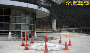 The Museum of Construction, with newly laid mosaic outside. |
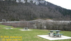 Picnic areas at the Lac du Sylvan aire, A40 |
||||
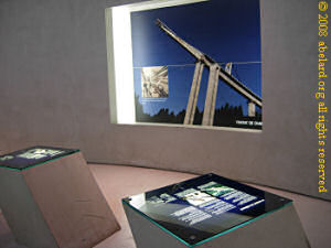 Display showing viaduct construction methods |
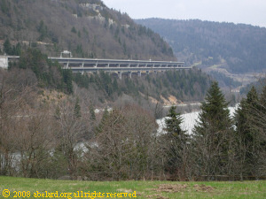 View of the Viaduct de Sylvan from the picnic area |
||||
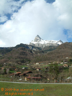
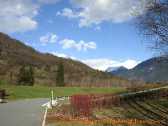 Above: in the N205 aire Right: traditional dwellings, with the Aiguille de Varan in the distance |
 |
||||
There’s a nice aire on the portion of the RN205 [or N205] going east before the Mont Blanc tunnel. Its small, but has the most spectacular views of mountains to the north and to the south, including Mont Blanc. The northern view includes many farmhouses traditional to this area. There are panoramic pictorial maps that show the names of the surrounding peaks.
Just before you reach the turn-off to the Mont Blanc tunnel road, on the right, there is a turn-off to an open air café. [Note, we have not visited for several years, so cannot guarantee that the café is still functioning.] Park by the at the bottom, and mount the footpath to a café whose backdrop is the glacier below Mont Blanc. Even in bright sunshine, there is a certain chill to the air but the ambience is peaceful and relaxing. The zigzag road, shown on the map above, must be negotiated carefully. You will be coming up a steep hill with lorries both going up and down. Those going up will be labouring to climb the hill, while those coming down will be racing after the enforced speed limits of the Mont Blanc tunnel. Further, the drivers are likely to be continental, maybe even Italian, and can be trusted to drive with little care for others. [Remember, according to an Italian, the reason for the excellent Italian hospitals is the large number of road accidents.] Going up this zigzag road, abelard.org met going downhill, a lorry overtaking another lorry on one of the blind zigzag bends - not funny. Downhill lorry racers also cling to your exhaust pipe to intimidate you into driving ever faster. Other Italian driving habits include overtaking on the inside [undertaking] a car that is preparing to overtake another vehicle, thus slaloming around both vehicles. Italians also take little notice of traffic lights and other controls at road junctions. Italian drivers can drive but are mad, whereas French drivers cannot drive. the mont blanc tunnelThe Mont Blanc tunnel is 1.6 kilometres/7.25 miles long, 8.6 metres/28.2 ft wide, and 4.35 metres/14.3 ft high. When opened in 1965, this tunnel was the longest road tunnel in the world. Safety measures: Since the mortal 53-hour fire within the Mont Blanc tunnel in 1999, when 39 people died after a lorry caught fire deep in the tunnel, safety has been much improved.
Safety distance: All vehicles must keep150 metres between them from each entrance of the tunnel. To ensure this, the toll barriers are timed to let a vehicle pass through about every 7 seconds. Thus at busy times, traffic can back up at the entrance areas. Other safety points:
Tolls: These can only be paid with main credit cards or cash (Euros, Swiss Francs), and exceptionally with a bank cheque on the French side. Current toll costs [note: Course simple means one way; Aller-retour means both directions]. visiting switzerland
Note that, as in Italy, the colours of road signs are the inverse of the colours used in France and the UK. Here in Switzerland, motorway signs are in green and road signs are in blue! Also, Switzerland has four official languages - English, French, German and Italian, so look forward to practicing your multilingual skills. notre dame cathedral, lausanneRegarded as the most beautiful Gothic cathedral in Switzerland, this building has arguably one of the most impressive rose windows in the world. It has five towers, the central one being 75 metres/246ft high. The main doorway (originally from the16th century) and the Apostles’ or Painted doorway (originally from the 13th century) are decorated with fine sculptured decoration. [Lausanne is about 50 km from Geneva.] |
|||||
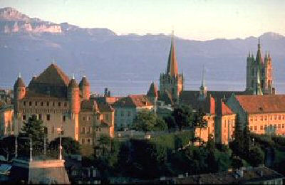 Lausanne cathedral. Image: epfl.ch |
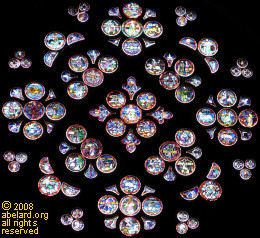 rose window, 13th century |
||||
related pages: |
|||||
end notes
|
|||||
|
|
|
|||
| abstracts | briefings | information | headlines | loud music & hearing damage | children & television violence | what is memory, and intelligence? | about abelard |
© abelard, 2009, 17 february the address for this document is https://www.abelard.org/france/motorway-aires17-a40_a42.php |