|
|
|
|
|
|
||
|
|
|
|
|
france’s western isles:île d’oleron |
|
|
|
|
||
|
related pages : |
||||||||
île de ré and île d’oleronOn the western edge of France, and facing into the Atlantic Ocean, these two islands are remote from, yet close to mainland French society. Both islands were part of the English empire of the 13th and 14th centuries. Both islands are now connected to the mainland by modern, arching bridges. Both islands rely on tourism and marine industries for the most part of their incomes. Both are somewhat remeniscent of the British Channel Islands, with sandy beaches, low road speed limits, little high street commercal development, white or brightly painted cottages in narrow-laned villages, and lots of sunshine. But here, the similarities end. The Île d’Oleron, the larger of these two islands, has been largely ignored by rich holidaying Parisians because there is no large or fashionable town nearby. As a result, although it is a popular holiday destination, Île d’Oleron has a neglected feel, and there is a certain scruffiness. île d’oleron
Oleron is the second largest island off France’s mainland [Corsica being the largest], with an area of 179 km²/63 miles². Oleron is 30 km/19 miles long and is 8 km/5 miles at its widest. Its population is almost 20,000. The Île d’Oleron is more wild and a little less ‘domesticated’ than its smaller island neighbour, the Île de Ré. There is more of a feel that the island is untouched and so ‘undiscovered’, despite the population increasing between eight and sixteen times at the height of summer. With an average of 2,200 hours of sunshine a year, the island is nicknamed “the Luminous”. The Île d'Oléron is also a popular tourist destination with its many beaches and sunny climate, particularly from July to September. Besides tourism, the main resources of the island are the oysters, aquaculture, the cultivation of early vegetables and vines. climateOléron, the southernmost island in the French Atlantic coast, together with the Île de Ré and coastal Charente-Maritime, is characterised by mild winters, especially in the south of the island, and refreshing summers. The islands of Ré and Oleron ‘enclose’ the strait of Antioch, a small Mediterranean sea that is warmed easily by the nearby Gulf Stream, giving good weather conditions with a narrow temperature range. The favorable climatic conditions create a Mediterranean micro-climate where vegetation more common to more southerly regions grow. Laurel rose (oleander), sun rose, yuccas, and mimosas grow here. Trees include holm oaks, eucalyptus, palms, figs, and orange trees. Because of these fragrant flowering plants, Île d’Oleron is described as the “perfumed isle”. There is a daily online metéo [weather forecast] service (in French, but pretty intuitive). This link is to the forecast for Saint-Pierre-d’Oleron. Mimosa is so abundant that during February each year, there is a Mimosa festival at St. Trojan. In 2010, it will be from 19th to 21th February. The festivities include a concert, bands in the street (note that these will probably be the very jolly, local brass baands), an evening dance, a fun fair and, of course, a parade with flower-covered floats, fancy dress and folklore groups. St Trojan is also known for its ‘Little Train’ that runs on 12 km of .60m-wide track that goes down to the coastline of the Pertuis de Maumusson. This width of track was invented in 1857, the trains then being used to remove sugar beet from the waterlogged fields. oysters - les huitres
Île d’Oleron still produces about 35,000 tonnes of oysters a year, despite diseases in previous years twice nearly destroying the oyster population. Re-stocking with oysters from Japan has helped revive the industry. However, there is still a run-down air to much of the island’s oyster industry areas. As part of making these areas more attractive to visitors, huts are now being restored and repainted. As functional buildings, they are gradually being replaced by buildings in concrete that are larger and more practical.
Many of the oyster beds developed from abandoned salt beds, which filled with brackish water, nutritious to oysters. Oystermen levelled and partitioned with dykes the flooded salt flats into ‘water pens’ or claires. These are connected with a canal network drawing in nutritious brackish sea water for refining oysters. The refining, over weeks or even months, is the last stage in oyster culture. This period allows growth to finish, and seaweed [Haslea Ostrearia] in the water to change the oyster flesh colour to green. |
|||||||||
The oyster beds on the island make fantastical patterns, which can be seen on the Google satellite map of Oleron. The oyster beds can be seen covering much of the eastern and southern parts of the island. There are more oyster beds in the straits to the south of the viaduct to the mainland, visible at low tide [photo below].
As well as inland oyster beds, this important marine industry, part of the Marennes-Oleron oyster region, includes the nearby Seudre and Charente estuaries and the narrow sea channel between the mainland and the Île d’Oleron. Over some 15,000 acres/6,000 hectares, between 45,000 to 60,000 tonnes of oysters are produced, as well as large quantities of seed oysters which are then grown on here and in other oyster-producing regions. The Marennes-Oleron oyster region produces 45% of France’s oyster production.
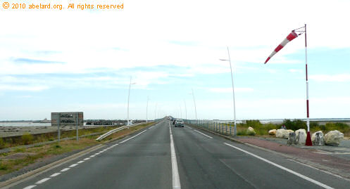
île d'oléron bridge
Since 1966, the Île d’Oleron has been connected to the mainland by a road bridge. When built, at 2,862 m /9,390 ft, it was the longest bridge in France. It is now the third longest, after the Saint-Nazaire bridge and the Ile de Ré bridge. It has been toll-free since 1991.
oleron - then and nowhigh-tide fishing - the eclusesAn écluse, fish lock, is stone walling set along the shoreline to catch fish by trapping them as the tide falls. The long walls are in the shape of a horseshoe, 500 m to 1 km long. This is a traditional fishing method, existing since the Middle Ages in the Charente-Maritime region. In 2009, about a dozen écluses are still operating on the Île de Ré, while there are a few more on the Île d’Oleron. The exact number varies on the source.
This map, drawn in the 17th century, shows the écluses around the north of the island. The earliest records come from the 14th century. On the western side of the island of Oleron, where the ‘wild coast’ is battered by ocean currents and prevailing winds from the southwest, traditional fishing is difficult to practise on the rocky foreshore, using nets supported by stakes driven into the shore or wicker fences. So instead, the islanders used a form of trap adapted to this situation. how an écluse works It only remains for the écluseur [écluse fisherman] to corner the fish with a small net that is held in both hands, a trill or trilla", then slaughter the fish with his espiot (a knife with a blade hooked at its end) and put it in his gourbeille (a narrow-mouthed wicker basket). Fishes caught include sole, seabass, mullet, whiting, squid, garfish, conger, skate and sea bream. Shellfish such as oysters and mussels grow on the walls built in ‘dry-walling’ technique [without cement]. Because the interlocking stones support each other, constant maintenance is needed to make sure the battering tides, and roaming tourists, do not breach the wall’s integrity. These walls that appear so strong, are in fact very fragile. As a visitor, do not move stones, or even shells that form a real natural cement. This type of construction has developed along the coasts of the Channel and the Atlantic coast. In the Charente straits [pertuis], the coastal inhabitants built écluses in large numbers, especially on the Ré, Aix and Oleron islands. The enclosures also formed a natural barrier against the beating swell of the ocean. The gradual disappearance of écluses from the nineteenth century resulted in erosion and a major change of the coastline they once protected. The écluses are marked with numbered poles, the number identifying the fisherman working that écluse. In 1850, there were 237 écluses on the Île d'Oleron. At the end of the nineteenth century, there were 140 locks on the Île de Ré and 180 on the Île d’Oleron. Today, there remains no more than 12 on the Île de Ré and 14 on the Île d’Oleron. Ecluses have disappeared elsewhere. There are guided tours from the Chassiron lighthouse todiscover the foreshore and the écluses. St. Georges d’Oleron3 March 2010: after Storm Xanthia. We think that the photo below was taken somewhere in the region of St Georges d’Oleron, but actually shows a random hamlet.
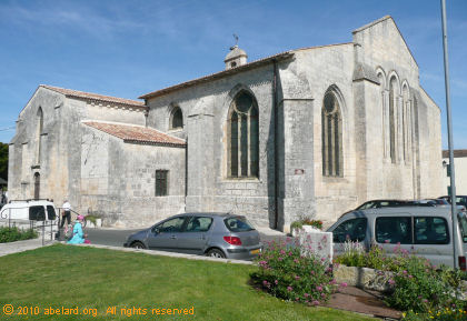
The Romanesque church of Saint-Georges d’Oleron has been an Historic Monument since 1931. The nave is the original church, built in the eleventh century, and fortified against pirates . The nave was completed in the thirteenth century and Eleanor of Aquitaine gave it to the Abbaye aux Dames de Saintes, which completed the work. In the sixteenth and seventeenth centuries, the church was suffered under the religious wars that raged in Oléron like elsewhere, being robbed and mutilated several times. Requisitioned during the 1789 Revolution, the church served as a barn, then it was restored for worship in 1800. Major restoration started in 1968. It includes rebuilding traditional roofing, restoration of the whitewashed and timbered vault, installation of roof guttering, renovation of the bell tower and installation of the windvane.
La Continièrethe portIn the early eighteenth century, the port of La Cotinière was composed of a pair of écluses to the west, and a flotilla of boats fishing for sardines. Enlarged in 1982, now the port is home to about 75 trawlers, trollers (net-free fishing boats using individual hooks and lines), and side-trawlers (as opposed to stern-trawlers) which make La Continière the largest port of the department of Charnte-Maritime. The annual catch landed here is more than 4,300 tonnes of fish. The return of the fishing ships is always interesting - the nets are spread on the ground to dry and evry day there is an electronic auction, sometimes attended by over 40 buyers. The electronic auction is one of the most modern in France. It takes place from Monday to Friday from 6:00 am to 4pm (16:00). It is worth a visit, with box upon box of oysters, fish and shellfish, all fresh from the sea, ranged on the quayside for inspection before and during the auction bids. La Cotinière church
This new church of Notre-Dame-de-la-Mer, built in 1967, has a triangular plan with the belfry, porch and vestry built outside the three sides as part of a second triangle. Thus, the complete floor plan is a Star of David. The windows were made by Jean Lesquibe from Anglet, with MartinGranel and Job Guével, finishing in 1968. The church provides the dual function as a place of worship for many summer visitors, and as a place of remembrance for sailors perished at sea.
chassiron lighthouseLighthouse Chassiron is the main lighthouse of Oleron. It replaces a tower built at the initiative of Colbert in the seventeenth century with two lighting bonfires. In operation since 1836, its name pays homage to Baron Charles de Chassiron. Painted white for nearly a century, it was sometimes confused with the Phare des Baleines lighthouse on the Île de Ré. To avoid accidents, black stripes were added to the Chassiron lighthouse. Chassiron lighthouse is over 46 metres high, and visible from more than thirty miles in clear weather. It was automated in 1998. You can climb its 224 steps to top and its splendid panoramic view. There is a museum and exhibition area at the base of the lighthouse, , together with a small gift and produce shop. The lighthouse gardens are organised as a compass, developing themes from vineyards and garden. Fort BoyardFort Boyard is a strategic fort built on the open sea off the Oléron coast. It was started in 1801, only being completed in 1851.
|
|||||||||
| abstracts | briefings | information | headlines | loud music & hearing damage | children & television violence | what is memory, and intelligence? | about abelard |
© abelard, 2009, 3 March the address for this document is https://www.abelard.org/france/ile_d_oleron.php 2340 words |


 in the Baudissiere area. Image: Google")