

 |
 |
 |
 |
 |
 |
||
 |
 |
 |
 |
 |
transbordeur/transporter bridges in
France and the world 2:
|
|
|
related pages: transbordeur/transporter bridges in France and the world 1: why, who, when, where |
 |
|
|
francenew : Germans
in France - St. Quentin cathedral Germans
in France
Gustave
Eiffel’s first work: the Eiffel passerelle, Bordeaux
a
dream unfulfilled - the transporter bridge [pont transbordeur],
Bordeaux |
A transbordeur bridge, or transporter bridge, is also known as a suspended car bridge, or a ferry bridge, or an aerial transfer bridge; the French term is un pont à transbordeur. Such a bridge has two tall metal pylons with a horizontal travelway fixed high above the river. A gondola (or nacelle, or platform) is suspended from a shuttle, usually powered by electricity, that runs along the travelway. The gondola provides transport across the river, while the bridge itself still allows large ship traffic, such as sailing ships, to pass up and down the river. I am aware of at least twenty-one transbordeur bridges having been built around the world, seven being in France [Bordeaux, Brest, Marseilles, Nantes, Rochefort, Rouen, and a minature one at Montceau-les-Mines] and five in the UK. In all, seven transbordeur bridges are still working today. The bridge at Duluth, Minnesota, although it is now an aerial lift bridge, sort of makes an eighth. The seven are
Puente de Vascaya, Portugalete |
|
||
 the Viscaya bridge, with the gondola in mid-trajectory |
||||
a
fifth bridge coming to Bordeaux: pont Chaban-Delmas,
a new vertical lift bridge the
6th bridge at Rouen: Pont Gustave Flaubert,
Ile
de France, Paris: in the context of Abelard and of French
cathedrals France’s western isles: Ile de Ré France’s western iles: Ile d’Oleron
|
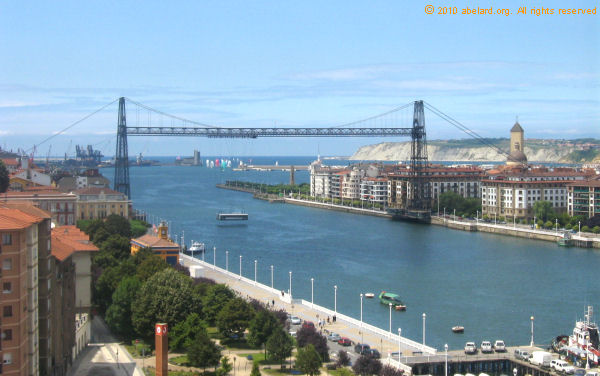
Opened in 1893, the Vizcaya Bridge was the first transporter bridge ever built, at Portugalete near Bilbao in northern Spain, and it is still functioning. In the nineteenth century, it was the means for workers to cross the river, to and from work every day. Being poor, they would forego paying the one peseta price, and climb up to cross by the high footway. Many would do this, taking their bicycle, twice a day - all to save two pesetas a day. [On the eastern shore - to the right in the photo above - is Las Arenas, while on the western shore is Portugalete.] Now lifts have been installed in both towers, so confident souls can walk across, 50 metres above the river Nervion, and enjoy the views across the port and Abra Bay. Locally, the bridge is called la Puente Colgante or Suspension Bridge, after the previous bridge to the transbordeur bridge. This bridge was declared an UNESCO World Heritage site in 2006.
The Vizcaya Bridge was used to move merchandise across the river in the industrial area. The car now is the third since the commissioning: it dates from 1950. It is suspended by cables from the trackway above. The bridge is maintained under the Industrial Heritage Agency. The trackway was destroyed during the Spanish civil war, to be reconstructed from 1939 to 1941, the engineer being J. Juan Aracil. The gondola is now made of aluminium to lighten its weight. The anchorages for the bridge are located behind the houses in the city, so the cables stretch over the rooftops. To avoid this, in Marseilles and Nantes, where there was limited space, Arnodin constructed his transborder bridges using braces and counterweights. statistics, Puente Vascaya
Chicago Sky Ride, 1933The Sky Ride was more a fair ride than it was a bridge, as well as being of particular engineering interest. Passengers rode in 12 double-decker cabins called “Rocket Cars”. These travelled continuously round, including round the towers, except when receiving a new load of passengers, a bit like a horizontal giant ferris wheel, such as the London Eye. |
|
||
|
|
||||
The Rocket Cars rode, suspended 200 feet above the ground, from a horizontal cable. Now normally, when cables are secured at either end, the cable hangs in a parabolic curve. On the Sky Ride, catenary cables were used, distributing the load so the cables formed level tracks. The catenary cables were supported by a complex of cables originating from the two tall towers at either end of the bridge. (Each tower had an observation platform at its summit.)
rochefort-martrou, rochefort-sur-mèrThis bridge was built over the fast-flowing River Charente, which at Martrou is 160 metres wide. Several previous projects to bridge the river near here had failed because of the French Navy’s strict requirement that there be a space of least 50 metres between bridge and water at high tide. The Navy did not want to be obliged to demast when passing under any bridge. In 1739, there are records of a ferry to take carts, coaches, people, animals and foodstuff, for selling at the Rochefort market, while a 1842 tunnel project was abandoned. It was only after Frederick Arnodin had submitted his patent for “a transbordeur bridge system for crossing maritime waterways” [1887] that an efficient solution for crossing the river was found. In 1927, the steam engines that provided the power were replaced by electric engines. In 1934, during repairs, the bridge was strengthened to carry 16 tonnes, rather than a 14 tonne payload. The transporter bridge was abandoned in 1967 in favour of a vertical lift bridge. In its turn, this was replaced by a modern bridge in 1991.
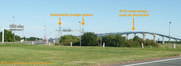
This bridge is a 1,200-metre long, four-lane bridge - the Pont de Rochefort, or Pont de la Charente. At first, a toll was charged, but this was later stopped.
|
|
|||
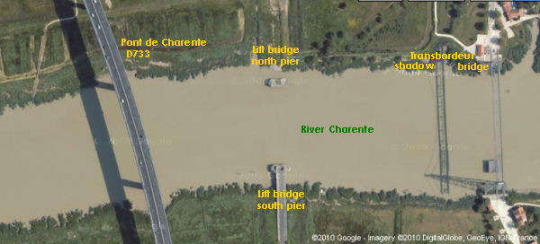
 Google satellite image of the three bridges on the Charente river near Rochefort Note that ‘accountants’ may quibble that, in fact, there are not three bridges pictured, but the remains of the lift bridge counts as one for me! |
||||
Meanwhile, the transbordeur bridge was classified as a Historic Monument in 1976 and so saved from the demolition threatened since its disuse. By 1994, this bridge was refurbished, and it is now used by pedestrians and cyclists during the summer months. From the end of 2009, major restoration work has taken place, replacing metal and woodwork dating from the start of the bridge’s construction in 1898. The bridge should reopen on the 5th June, 2010. A part of the restoration is the wheels through which the cables pass, the diameter of these having worn down to be 67 cm, instead of the original diameter of 80 cm.Rochefort-Martrou transbordeur bridge statistics and interesting facts
|
||||
 |
||||
access Ticket and souvenirs are available from the building on the north side/rive droit of the River Charente, just follow the signs to the Pont transbordeur from the D733. The approach road to the bridge is lined by a row of typically Charente houses. The crossing takes 3:40 minutes, so rather just doing a there-and-back trip, you may decide to walk on the south river bank, perhaps going to the nearby commune, Echillais. On the north bank, there is also the Chemin de Charente, a signposted footpath, enabling walkers to follow the river downstream and so see the bridges from afar, as well as enjoying this estuary landscape.
short glossary
|
advertising disclaimer |
|||
| You are here: transbordeur/transporter bridges in France and the world: focus on Portugalete, Chicago, Rochefort-Martrou < Architecture < Home |
© abelard, 2010, 05 june the address for this document is https://www.abelard.org/architecture/transbordeur_bridges2.php |