france
new! Cathedrale Saint-Gatien at Tours 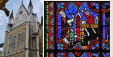
 updated: Romanesque churches and cathedrals in south-west France updated: Romanesque churches and cathedrals in south-west France
the perpendicular or English style of cathedral 
the fire at the cathedral of Notre-Dame de Paris

cathedral giants - Amiens and Beauvais
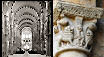
Stone tracery in church and
cathedral construction 
stone in church and cathedral construction stained glass and cathedrals in Normandy 
fortified churches, mostly in Les Landes
cathedral labyrinths and mazes in France
using metal in gothic cathedral construction
Germans in France
cathedral destruction during the French revolution, subsidiary page to Germans in France

on first arriving in France - driving
France is not England
paying at the péage (toll station)

Transbordeur bridges in France and the world 2: focus on Portugalete, Chicago,
Rochefort-Martrou
Gustave Eiffel’s first work: the Eiffel passerelle, Bordeaux
a fifth bridge coming to Bordeaux: pont Chaban-Delmas, a new vertical lift bridge
France’s western isles: Ile de Ré
France’s western iles: Ile d’Oleron
Ile de France, Paris: in the context of Abelard and of French cathedrals
short biography of Pierre (Peter) Abelard
Marianne - a French national symbol, with French definitive stamps
la Belle Epoque
Grand Palais, Paris


Pic du Midi - observing stars clearly, A64
Carcassonne, A61: world heritage fortified city
Futuroscope
Vulcania
Space City, Toulouse
the French umbrella & Aurillac
50 years old:
Citroën DS
the Citroën 2CV:
a French motoring icon
the forest as seen by Francois Mauriac, and today
Les Landes, places and playtime
roundabout art of Les Landes
Hermès scarves

bastide towns
mardi gras! carnival in Basque country
country life in France: the poultry fair
what a hair cut! m & french pop/rock

Le Tour de France: cycling tactics
|
the
department and forest of landes
The lowly-populated and highly forested French Département
of “Les Landes”, Dept. 40, is part of the
region of Aquitaine. You can see some factlets on the
roundabout art of les landes page.

The Département [1]
of Les Landes, the second largest department in France,
with an area of about a million hectares, was created
in 1790 by uniting administratively a mosaic of fourteen
small local pays - ‘countries’: Grande
Lande, Petite Lande, Marsan, Bas-Armagnac, Gabardan, Tursan,
Albert, Born, Marensin, Maremne, Chalosse, Seignaux, Gosse
and Orthe [2].
The
River Adour is the dividing line between the two very
different landscapes that make up Les Landes - moors and
forest to its north and hilly farming land to its south.
To the north, on a base of consolidated limestone sediment
(alios), covered by sand, grows the forest in Born, Marensin,
Maremne, Grande Lande and Marsan. To the east, this area
is bordered by Bas-Armagnac. To the south, where the land
is fertile and hilly, with neither alios nor sand, the
local regions are Gosse, Seignaux, Chalosse and Tursan.
On the
following map, ‘hover and click’ for more
information
about the pays of Les Landes.
. Original image: EDF")
Departement of Les Landes, showing
its component regions (pays)
The low population in Les Landes, about 300,000 people,
has not changed much for the last 150 years, the larger
portion being in the regions south of the River Adour,
the pays of Chalosse and Tursan.
Before becoming the greatest extent of forest in France
during the nineteenth century, this unfertile land of
moving sandy ground truly merited the name of moor - la
lande in French. It was known as the French Sahara.
It attracted neither immigration, nor commercial traffic.
“Crossing the moor was dreaded by pilgrims
going to Saint-Jacques-de-Compostelle; they reported
that they could find no bread, no meat, no fountains.
It was a flat ground of marshes.... with practically
no paths, the pilgrims were often up to the knees in
the invading sea sand.”
It was a vast, fairly flat landscape of barren moors,
becoming marshland in winter when the rivers swelled and
flooded.
“Formerly, stagnant waters and marshes located
on the greatest part of the departement, made sickly
the unfortunate classes who vegetated there and of whom
most died of fevers; while the resin workers, thin and
doomed to an early death, lived in inadequate cabins
in the damp forests.”
There were various experiments to control the sogginess
and unsalubriousness of the region, together with agricultural
experiments - rice, mulberry trees, tobacco, peanuts -
which all failed. [3]
Another description comes from Cloisters
and cathedrals of the south of France by Elise
Whitlock Rose.
“Lying inland from the Gulf of Gascony is a stretch
of territory called "the Landes." Formerly
it was bordered by great, lonely sand dunes which protected
it from the sea. Behind them lay the "bad lands"
which were, at times, torrid Saharas, where strange
hot springs, eerie bogs, and marshes, stretches of vast
pine forests, and plains that extended to a dreary,
sealike immensity, made up the landscape. Sands, blown
by harsh sea winds, covered pools of stagnant water
and concealed them from the eye of the unfortunate pedestrian;
and, sweeping onward, these same winds often covered
entire villages with the sand, and compelled the poor
inhabitants to retreat and re-build elsewhere. These
encroachments, which the ignorant were powerless to
check, made the district one of waste and awesome terror,
a desert whose monotony was broken only by the terrifying
phenomena of sand-storm, and waters bubbling in inexplicable
heat. Through industry and science the human misery
of these little steppes has been decreased; and before
this "progress of cultivation" the whole physiognomy
of the country has changed. Forests break the long lines
of the plains, dunes are becoming little, rounded, wooded
hills; and if the new growth seems somewhat meagre and
the land still barren, its desert-like appearance is
disappearing and it is gradually losing its mournful
distinctiveness and curious industries.” [p.191]
The original forest grew naturally along the rivers and
on the coastline. In 1800, it covered 250,000 hectares.
The rest of the department’s countryside consisted
of moorland, more or less marshy, the uncontested domain
of the shepherd. To move around this unhappy landscape,
the shepherds had to use stilts.
At the sea edge, the moving dunes, eroded by the sea breeze
and the ‘currents’ [4],
invaded, suffocated and buried villages and the forest.
It was in order to protect themselves from the steadily
encroaching sand, that the locals stabilised the sand and
channeled the ‘currents’ - the little streams
that run down to the Atlantic Ocean.
Here and there, fixing the dunes was done from the eighteenth
century, but it was only with the creation by the State
of a Commission of Dunes that the works, inspired by those
of local Landais proprietors, advanced seriously. In 1817,
4,000 hectares of sand were fixed and in 1825, all the
coastline was stabilised. From 1862, the Waters and Forests
Service successfully maintained the coastal dune line.
(The events of 1914-18 and 1939-45 damaged the dunes,
and it was only in 1950 that the dunes’ ideal profile
was returned with the work of bulldozers.) Note that this
history is somewhat different from what happened further
north in Les Landes, near the metropolis of Bordeaux
and the Archachon Bassin.
It took many decades before
the work to dry the Landais marshes and plant them with
forests was finished. An unhealthy place, the marshes
were the seat of sicknesses such as malaria, which in
48 hours took the mayor of Lit-et-Mixe and his son. These
two were the brother-in-law and nephew of Henri Crouzet,
whom Emperor Napoleon
III had appointed to clean up Les Landes. As part of his
love for the department of Les Landes, Napoleon III bought
a 8,000 hectare area of uncultivated land in the “Grande
Lande” that he baptised Solférino, and at
its head he put Henri Crouzet.
This man, who had an excellent knowledge of the land
and the drainage done by the Landais inhabitants, is considered
to be the inspiration for the 1857 law. At Solférino,
he succeeded so well in his land clean-up that the imperial
domain became a first order experimental zone. Crouzet
created numerous agricultural roads, established new cultivation
and dried the Orx Marsh, to the south of Les Landes. Crouzet
had the benefit of marrying a descendant of L.M. Desbiey
who did the first works to fix dunes in the 18th century.
The law imposed by Emperor Napoleon III in 1857, ordered
all the communes [5] of Gascogne
Landes, not just the coastline, be drained and then planted
with maritime
pines, making the land useable and rich. Bit by bit,
pines covered
Les Landes, changing the landscape and reducing the
expanse of more than 100,000 hectares of moors. This made
room for the young forest that would become one of the
largest industrial forests in Europe. |
advertising disclaimer
|
 Les Landes - the Moor; before the industrial
pine forest was planted systematically from the mid-19th century
Les Landes - the Moor; before the industrial
pine forest was planted systematically from the mid-19th century |
life
before the forestBefore the forest, there were
isolated villages and homestead groupings, with few trees, dotted
about the bleak, marshy expanses. The Landes - the marshes
- were wet, unhealthy and practically barren of nutriments for
plants or animals. Villages developed near rivers where the soil
was slightly better and where communication with others was more
likely. The inhabitants eaked their living from keeping sheep.
Later, the isolated villages on huge stretches of flat moors would
change to being isolated open areas enclosed in hectare upon hectare
of pine forest. The amount of space available for organizing
the villages and its homesteads determined community relationships.
In the Grande Lande, the farm was arranged
on an “airial”, an extensive, unenclosed and grassed
area centred on a farmhouse, scattered with trees. Each airial
could be considerably far away from the next, the population density
being very low in this part of the department. In Chalosse,
property organisation was different, as was the architecture and
house interiors. Relationships with the ‘Other’ -
people not from near by - whoever that might be, were also determined
by these factors. |
the
airial
Plan of a Landais airial
Airials
in the Grande Lande followed a plan that included, as well as
the main farmhouse and other dwellings for other families and
workers, a stable and barn for tools, other outhouses, such as
a bread oven, workshops and various further storage buildings.
The airial would be a fairly self-contained community, supporting
the extended family and other inhabitants by trading labour and
produce that they grew or harvested. Amongst the cash crops
and industries were wool, beehive products - honey and beeswax,
food products and fertiliser (from the sheep), and above all pine
resin. The main food crops were grown on fields extending
3 to 5 hectares, with two different crops grown on the same land
by staggering sowing times and using the furrows as well as the
ploughed ridges. In autumn, having spread manure
collected from the sheep during the summer, the fields were
broadcast sown with rye, then ploughed into ridges. In spring,
a second crop, such as millet or panis (panic grass,
similar to millet) was sown. The crops were harvested in summer,
and in autumn the cycle began again - leaving land to rest and
lie fallow was not known. The rye and other harvested cereal
was ground into flour and baked into bread using a large communal
oven in a separate building. As well as the many maritme
pines for resin and lumber, each airial would have at least one
parasol pine [also known as the umbrella pine], a different pine
species from the maritime pine, from which pignons, pine
seeds are harvested. In the photograph below, the spreading parasol
pine in the foreground contrasts with the much narrower maritime
pines in the distance.   Cattle
were regarded as valuable, and even noble, animals and so were
treated with greater respect than the multitudes of sheep. For
instance during the winter, the animals were fed through a special
opening from the living room to the beasts’s quarters -
the estoulis - and everyone benefited from the warmth
of the fire.

|
|
marqueze
- airial and eco-museum  At
Marqueze, close to Sabres in the heart of the Grande Lande, is
one of three parts of the Eco-Museum - the Museum for the history
of the local Landes economy. The Marqueze site focuses on living
in Les Landes both before and after the coming of the forest.
It is a large functioning airial, accessible only
by a short
train ride, on a train and line classed as a historic monument,
through the surrounding pine forest. The airial is a living model
of rural society in the Grande Lande during the 19th century.
Here, you can visit houses, shepherds’ homes and kitchen
gardens. There are people plying their trade: the baker, the weaver,
the oxen-wrangler and the resineur,
who are guardians of the traditions and the skills, the savoir-faire. At
Marqueze, close to Sabres in the heart of the Grande Lande, is
one of three parts of the Eco-Museum - the Museum for the history
of the local Landes economy. The Marqueze site focuses on living
in Les Landes both before and after the coming of the forest.
It is a large functioning airial, accessible only
by a short
train ride, on a train and line classed as a historic monument,
through the surrounding pine forest. The airial is a living model
of rural society in the Grande Lande during the 19th century.
Here, you can visit houses, shepherds’ homes and kitchen
gardens. There are people plying their trade: the baker, the weaver,
the oxen-wrangler and the resineur,
who are guardians of the traditions and the skills, the savoir-faire.
The other two parts of the Eco-Museum are the Resin
Products Factory at Luxey, and the forestry
activities centre nearby at Garein.
Plan
of the Marqueze Eco-Museum, near Sabres |
 
|
sheep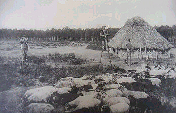 There
were few ways to earn a living in this unhealthy, temperate desert,
keeping flocks of sheep being a major occupation. In 1850, there
were 1 million sheep; by 1862, there were 527,000, and by 1890
this had reduced to 295,000 as forest replaced the frugal moor
pastures. The land - mostly marsh and sandy moors - was so poor
that it would only support one animal per hectare. Thus, the shepherds
and their flocks roamed widely over the area, moving up to 20
kilometres a day over communal moorlands to find sufficient grazing
for the flock. At
night, the sheep were penned in a sheepfold, which ensured that
the animals’ manure was not dispersed unnecessarily. The
manure was the main crop from the sheep, being used on the fields. There
were few ways to earn a living in this unhealthy, temperate desert,
keeping flocks of sheep being a major occupation. In 1850, there
were 1 million sheep; by 1862, there were 527,000, and by 1890
this had reduced to 295,000 as forest replaced the frugal moor
pastures. The land - mostly marsh and sandy moors - was so poor
that it would only support one animal per hectare. Thus, the shepherds
and their flocks roamed widely over the area, moving up to 20
kilometres a day over communal moorlands to find sufficient grazing
for the flock. At
night, the sheep were penned in a sheepfold, which ensured that
the animals’ manure was not dispersed unnecessarily. The
manure was the main crop from the sheep, being used on the fields.
The output of twenty to thirty sheep was required to adequately
fertilise one hectare of the poor, acid Landais soil.
- 1 kilogram of rye bread fed an adult, a family of eight to
ten people would eat 4,000 kg rye bread a year.
- 3,200
kg flour are needed to make 4,000 kg bread.
- 4,000 kg rye
grains are ground to make 3,200 kg flour.
- 4 hectares of
land are needed to produce 4,000 kg rye grains.
- 60 tons
of manure are needed to fertilise 4 hectares of land.
- 100
sheep will produce 60 tons of fertiliser.
- 100 hectares
of moorland provide food for 100 sheep.
|
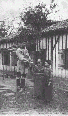
stilts
Shepherd on stilts, knitting , with his
flock.1905
Stilts first appeared well before the
forest, when Les Landes was an immense marshy country, very flat,
with the vegetation primarily consisting of grass and undergrowth.
Principally, it was shepherds who lived in this landscape. The
shepherds had several reasons for using stilts: - in
order to more easily make a path through the vegetation when the
shepherds travelled the long daily distances required by their
sheep-tending;
- to avoid wetting their feet in the marshes;
- but their main use was to be able to supervise their
flocks of sheep from afar.
|
 The
first records of stilts in Les Landes date from the beginning
of the 18th century. However, it is not known whether using stilts
was invented locally by the shepherds, or whether they were an
import, say from the Flemish region of Belgium, where stilts had
been used since the Middle Ages. The
first records of stilts in Les Landes date from the beginning
of the 18th century. However, it is not known whether using stilts
was invented locally by the shepherds, or whether they were an
import, say from the Flemish region of Belgium, where stilts had
been used since the Middle Ages. Landais stilts were made
from two pieces of wood: - the escasse (“leg”
in landais patois) from where comes the modern French name for
stilts: l’échasse; and
- the pé
paouse (“foot rest” in landais patois), which
is fixed on the escasse, generally giving a stilt height
ranging between 90 cm and 1 m 20.
The stilt user
attaches the stilt to his (or her) leg with two leather thin straps. Other
Landes inhabitants also used stilts to move around the marshy
landscape. For example, the postman as shown in this posed postcard. The
use of stilts by the shepherds for work purposes disappeared gradually
between the middle of the 19th and the beginning of the 20th century
with the establishment of the forest, which drained the marshes
and eliminated the pastures, and thus the sheep and their shepherds
on stilts. |
 But
during this time, the shepherds started to use stilts for games,
and they also mixed stilts and dances with the other villagers.
In 1889, Sylvain Dornon, a former shepherd turned baker, started
the first folk group on stilts in the park of the Moorish Casino
at Arcachon The spectacle started with sporting events and races,
and continued with dances. The first dance was Lou Quadrilh
dous Tchancats - the stilt-users’ quadrille. But
during this time, the shepherds started to use stilts for games,
and they also mixed stilts and dances with the other villagers.
In 1889, Sylvain Dornon, a former shepherd turned baker, started
the first folk group on stilts in the park of the Moorish Casino
at Arcachon The spectacle started with sporting events and races,
and continued with dances. The first dance was Lou Quadrilh
dous Tchancats - the stilt-users’ quadrille.
Sylvain
Dornon also performed various stunts to promote the use of stilts.
He went up the Eiffel Tower on his stilts during the
World Fair of 1889, and in 1891, walked from Paris to Moscow
via Vilno - 1830 miles or 2850 km - in 58 days.
| “The preparations did not take me a long time.
I manufactured myself two pairs of whitewood stilts, one which
measured 1 m 10 and weighed 3 kilo 200 (the pair), and on which
I accomplished all my voyage, and another pair which measured
1 m 80, that I dispatched in Moscow. I also dispatched two trunks
containing replacement linen and clothing, one to Berlin, the
other to Moscow. I got some good charts which I placed, with a
little linen and a loaded revolver, in a small yellow leather
satchel to be carried slung over my shoulder. On March 10 all
was ready. I had obtained for the voyage a solid costume that,
to add a picturesque note to it, I supplemented by the Landais
goatskin and beret.” | |
 Today, there are 21 Landais folk groups which continue the dances
on stilts of their ancestors, and other traditions. Stilt folk
group members also take part in the stilt races that are part
of the Challenge of the Federation of the Folk Groups Landais.
These races include the long-distance race of about 150 km from
Arcachon to Capbreton.
Today, there are 21 Landais folk groups which continue the dances
on stilts of their ancestors, and other traditions. Stilt folk
group members also take part in the stilt races that are part
of the Challenge of the Federation of the Folk Groups Landais.
These races include the long-distance race of about 150 km from
Arcachon to Capbreton.
Even a few years ago, stilt-dancing
groups would often give free displays of their art. Now, it is
unusual to find a free stilt-dancing display. The towns that invited
stilt-dancers to give a demonstration now will corral the dancers
in an enclosed arena or a pelote court,
demanding payment for the privilege for sitting on hard benches
amongst un-chosen company. [To the right: Stilt-dancing display,
at a folk festival.] life
with the forestThe suite of pages on Les
Landes - its forestry industry continues with Working
in the forest. The third page focuses on resinous
and other forest products. |
end
notes
- Département
- the above is the French way of spelling the word
that Anglo-Saxons spell as department.
Here at abelard.org, we use both
spellings when describing the French administrative
department, which is fairly equivalent to an American
state or British county..
- Grande
Lande
- In the centre of Les Landes, the large Moors
(la Grande Lande) comprises, from Gironde to the
doors of Dax,
a vast wooded area of pine forest, exploited since
the 19th century. The forest feeds various wood
industries, found above all around Sore, Pissos,
Sabres and Morcenx. The forestry activity is less
in the smaller towns, nestled in the middle of clearings
or in the picturesque valleys of the Eyre.
- Petite
Lande
- Fused to the east of the Grande Lande, the Petite
Lande has hills and valleys with a checkering of
meadows and cultivated fields surrounding well-kept
villages.
- Marsan
- Further south, the Marsan is watered by the Midouze
and its tributaries and characterised by steep-sided
valleys and their series of artificial meadows and
land cultivated to vines and cereals. There are
many livestock-farming tenant farms.
- Bas-Armagnac
- To the east of the department, are the hills of
Bas-Armagnac, with their well-known vines and including
neighbouring Villeneuve-de-Marsan and Labastide-d'Armagnac.
- Gabardan
- To the north of Bas-Armagnac, this region has
moors and broad-leafed forests, while from Estigrade
to Losse and Lubbon is a zone of étangs
(large ponds/small lakes) and dried marshes.
- Tursan
- region of the wine of the same name, which was
part of the dowry of Eleanor
of Aquitaine when she married Henry Plantagenet,
King of England.
- l’Albert
- Enclosed to the east by Petite and Grande Lande,
the the lords of Albret extended their frontiers
of their fief to the ocean in the 13th century.
The forest, punctuated by fields and meadows, covers
a great part of this primitive territory.
- Born
- Born has an attractive coastal region and vast
ponds (étangs) swollen by the courants
from the interior. Behind the lakes is sumptuous
forest, decked with undergrowth according to the
season with broom, gorse and heathers. Big market
towns and villages are bordered by orchards and
maize fields.
- Marensin
- This region ends a bit north of Soustons [an English
name - South Town] is similar to Born with its beaches,
lakes and refreshing courants. By the countryside
is more various, thanks to populations of cork-oaks
and rich land inland used for growing cereals and
raising livestock.
- Maremne
- Maremne includes, between Vieux-Boucau and Labenne,
the pretty seaside resorts of Hossegor and Capbreton
and pretty lakes with invaded by a sylvan landscape
of cork-oaks, laurels, mimosas and other rich vegetation
due to the mild climate. The fertile soil is well-suited
to maize.
- Chalosse
- Inhabited since paleolithic times, with undulating
farming land reminiscent of parts of middle England,
Chalosse also is crossed by Compostelle
pilgrims and, from the high hills, has magnificent
views to the ocean, the endless forest and even
to the distant Pyrenees.
- Seignaux,
Gosse and Orthe
are the small pays to the south of Les
Landes.
- Rice
grows successfully in the Carmargue region of Mediterranean
in France; mulberries were cultivated in the Lyon region
to feed the silkworms of the French silk industry; while
tobacco is grown commercially in the Dordogne. Growing
peanuts now succeeds to a small extent around Soustons
in Les Landes.
- Courant
- Current: a small river close to the coast and
cuts through the dunes to reach the ocean. A courant
often originates from an étang (large
pond) or lake.
- Commune
- used to describe local administrations, whether
a village, town, or district. The territory of a
local council.
- Cloisters and cathedrals
of the south of France by Elise Whitlock Rose,
published by G.P. Putnam’s Sons, the Knickerbocker
Press, 1906.
- The
opening times and prices for the 2006 season for all
three Eco-Museum sites. For the Marqueze site, the
opening times are based on the train timetable. The
times and prices can be your starting point for the
2007 season (31 March to 4 November 2007). When more
current information is available, abelard.org
will, of course, update our information.
- Pelote and
the fronton
A local sport, played in the southern and coastal regions
of Les Landes, but mostly in the Basque Country, in
Pyrenees Atlantique and north-western Spain. The game
has been exported to other parts of the world by Basque
emigrés.
A small, hard, leathered-covered ball, filled with a
wound rubber cord, is hit against a high wall, using
a sort of basket strapped to the hand, a paddle like
a ping-pong bat, or with the bare hand. When played
indoors, one side wall is also used. The bare-handed
players often have crippled hands as a result of the
violent hitting of the fast-moving ball. Outdoors, pelote
is played at the fronton, a tall, wide, marked wall,
with lines marked on its asphalt playing zone. There
are often tiers of seats for spectators. |
 
|
 Frontons: the two outdoor pelote courts
(above left and left) show typical Landais weather , with occasional
cloud bursts and thunderstorms.
Frontons: the two outdoor pelote courts
(above left and left) show typical Landais weather , with occasional
cloud bursts and thunderstorms.
The top left photo includes typical ‘brutalised’ trees
on the right. In France, trees are hard pruned, which results
in plentiful shade during the sunny, hot summer days, but during
winter the trees show their knobbly scars. Note that generally
the leaves from these trees are not just left to fall in autumn.
Instead, they are removed as part of the hard pruning regime.
The trees usually subjected to this treatment are plane trees
- Platanus species.
Top right: an indoor pelote court deep in Pyrenees Atlantiques,
being used for a folk display.
Bottom left: This fronton, next to the Mairie [town hall] on the
left, is flanked on both sides by rows of concrete seats, like
deep steps. Notice also the pruned trees in full foliage on the
right. |
Every town and village, large and small, in Basqueland
[Pays Basque] and among its close neighbours, aspires to build
its fronton, some indoors, many outdoors. Frontons of varying
size and grandeur become centres of entertainment and festivity,
ranging from communal barbeques and folk dancing to general partying.
Frontons are hang-outs for local teenagers, practising skateboarding
or practising their tennis strokes against the wall, and of course
for clashes in the local pelote leagues.
|


