france
new! Cathedrale Saint-Gatien at Tours 
 updated: Romanesque churches and cathedrals in south-west France updated: Romanesque churches and cathedrals in south-west France
the perpendicular or English style of cathedral 
the fire at the cathedral of Notre-Dame de Paris

cathedral giants - Amiens and Beauvais
Stone tracery in church and
cathedral construction 
stone in church and cathedral construction stained glass and cathedrals in Normandy 
fortified churches, mostly in Les Landes
cathedral labyrinths and mazes in France
using metal in gothic cathedral construction
Germans in France
cathedral destruction during the French revolution, subsidiary page to Germans in France

on first arriving in France - driving
France is not England
paying at the péage (toll station)

Transbordeur bridges in France and the world 2: focus on Portugalete, Chicago,
Rochefort-Martrou
Gustave Eiffel’s first work: the Eiffel passerelle, Bordeaux
a fifth bridge coming to Bordeaux: pont Chaban-Delmas, a new vertical lift bridge
France’s western isles: Ile de Ré
France’s western iles: Ile d’Oleron
Ile de France, Paris: in the context of Abelard and of French cathedrals
short biography of Pierre (Peter) Abelard
Marianne - a French national symbol, with French definitive stamps
la Belle Epoque
Grand Palais, Paris


Pic du Midi - observing stars clearly, A64
Carcassonne, A61: world heritage fortified city
Futuroscope
Vulcania
Space City, Toulouse
the French umbrella & Aurillac
50 years old:
Citroën DS
the Citroën 2CV:
a French motoring icon
the forest as seen by Francois Mauriac, and today
Les Landes, places and playtime
roundabout art of Les Landes
Hermès scarves

bastide towns
mardi gras! carnival in Basque country
country life in France: the poultry fair
what a hair cut! m & french pop/rock

Le Tour de France: cycling tactics
|
Pyrenees
national park -
parc national des Pyrénées
Much
of the Pyrenean heights of Hautes-Pyrénées [Département 65] is a National
Park, protected from construction and touristic over-use, with
a peripheral area extending into the foothills.
Here, even
though you are unlikely to see the animals themselves, there are
many signs of both supporters and opposers of the local larger
fauna - bears and wolves. Unfortunately, just a few years ago,
the last genetically indigeous Pyrenean female bear was shot by
a local farmer. The male cub survived at the time. Now, brown
bears from Slovenia are gradually being introduced. These have
bred so there are now about 15 Slovenian brown bears in the central
part of the Pyrenees, with four native bears in the Aspe valley.
Wolves are said to kill sheep put out to summer pastures. However,
our understanding is the shepherds no longer wtach daily, or nightly,
over their flocks so there might be some sympathy for the wild,
rather than the domesticated, animals.
There are also two
national parks in the Spanish Pyrenees: Aigüestortes i Estany
de Sant Maurici National Park and Ordesa y Monte Perdido National
Park.

The
Pyrenees National Park is shared with many holiday resorts specialising
in snow sports, particularly skiing and, now, snowboarding. The
towns, like Cauterets, Gedre or Gavarnie, may be at the edge of
the national park but the ski slopes are high in the National
Park, accessed by cable cars, or buckets on a wire, as they are
sometimes described!
Gavarnie
Gavarnie
is a base for walking in high mountains, admiring the spectacular
scenery, the jewel- like flowers, the soaring eagles. You might
even see a marmoset guarding its burrow. The Cirque de Garvarnie
is a two-hour walk from the village, or you can ride up on a mule.
For more experienced walkers, the High Pyrenean Walking Route
follows the heights, with refuges for overnight stops.
Cirque
de Gavarnie is a famous example of a cirque in the central Pyrenees,
in the Pyrenees National Park. The cirque is 800m wide (on the
deepest point) and about 3000m wide at the top. It incorporates
seventeen peaks that are over 3,000 metres, with the highest waterfall
in Europe at 423 metres - the Gavarnie Falls.
A major feature
of the cirque is La Brèche de Roland (Roland’s Breach,
also called the Roncevaux Pass), supposedly created by Roland,
a nephew of Charlemagne. According to legend, Roland owned a sword
reputed to be indestructable, that had previously belonged to
Hector of Troy. To prevent the sword falling into the hands of
the Sarasens, Roland attempted to destroy it by hacking at the
rocks. He managed to cut a gap 40 metres wide and 100 metres high.
Cauterets
Like
Gavarnie, Cauterets is walking territory during the warmer months,
but during the colder parts of the year, Cauterets is a major
skiing resort, for both cross-country and downhill skiing, with
cable-cars up to the pistes running all through the day, and visible
from town centre hotels.
As well as being a ski resort,
Cauterest is also a spa town. The thermal springs contain sulphur
and sodium silicate, being used to treat respiratory and skin
diseases, as well as rheumatism and other complaints.
A
local speciality are the flavoured boiled sweets, berlingots [the
name refers to the shape of the sweet]. These are made in several
sweet shops in the town, and you can watch the stages in making
striped boiled sweets - a quite extraordinary process. As well
as being able to buy bags and boxes of mixtures that you’ve
chosen, from at least one shop it is possible to order and have
sweets sent to your home.
Back to skiing - some ski slopes
are monitored by webcams, so visitors can check the weather conditions
before setting out to ski. |
advertising disclaimer |
snow
and other webcams
There are a number of cameras
filming both resort towns and the skiing pistes at several places
in the Pyrénées.
 For
example, there
are five cameras showing the pistes above Cauterets and one of
the town. [You need to have Java installed in your web browser.]
The cams repeat a half-minute recording, with the recording being
updated roughly every half hour to hour during daylight hours
(the camera for Cauterets town continues to operate after dark). For
example, there
are five cameras showing the pistes above Cauterets and one of
the town. [You need to have Java installed in your web browser.]
The cams repeat a half-minute recording, with the recording being
updated roughly every half hour to hour during daylight hours
(the camera for Cauterets town continues to operate after dark).
 In
1873, a weather station was set up on the Col de Sencours, below the Pic de Midi. The foundation
stone for the Observatory was laid five years later. This Observatory,
now listed natural site, has been opened to the public since 2000.
Thus, it is visitable, providing you do not mind riding in “a
bucket on a string” [a cable car]. The trip starts at 1
800 metres. Fifteen minutes later, you reach the Observatory at
an altitude of 2,877 metres for a two-hour visit. In
1873, a weather station was set up on the Col de Sencours, below the Pic de Midi. The foundation
stone for the Observatory was laid five years later. This Observatory,
now listed natural site, has been opened to the public since 2000.
Thus, it is visitable, providing you do not mind riding in “a
bucket on a string” [a cable car]. The trip starts at 1
800 metres. Fifteen minutes later, you reach the Observatory at
an altitude of 2,877 metres for a two-hour visit.
Here are
the most spectacular views across the snow-topped Pyrenees to
the plains southern France and north to the Massif Central foothills.
There is a museum and discovery area where you can understand
the astronmical research being done with the three telescopes,
including a solar telescope. There is also a restaurant, a snack
bar and a gift shop. Visitors should take both warm clothing and
sun glasses, and take account of being almost 1.8 miles higher
than sea level.
See also Pic
du Midi - observing space clearly for much more detail and
many illustrations.
 in the foothills in the foothills
Lourdes
The
most prominent feature used to be the fortified castle which rises
up from the centre of the town on a rocky escarpment. However,
with the burgeoning Christian fervour and attraction of this town,
there are now many religous edifices to compete for attention.
Lourdes
has the second greatest number of hotels in France after Paris
with about 270 establishments. After alleged apparitions of “Our
Lady of Lourdes” to Bernadette Soubirous in 1858, Lourdes
has developed into a major place of Christian pilgrimage. This
year, 2008, is the 150th anniversary of her ‘visions’.
Pau
Pau is birthplace of Henry
IV of France. His mother was Jeanne d’Albret, Queen of Navarre,
whose family titles included Navarre
and Béarn as well as the countdom of Foix, and whose
vast teritories included much of Les
Landes and extended around Agen,
to Périgord and to the viscomtdom of Limoges. Jeanne converted
to Huguenot Protestantism in 1560, seven years after the birth
of Henry. Henry of Navarre became the first Protestant to become
king of France, after converting to Catholicism, supposedly with
the comment, “Paris vaut bien une messe”
- “Paris is well worth a mass”.
English travellers
came to Pau from the late 18th century, to enjoy its climate and
healthy air, encouraged by Wellington, who had left a garrison
at Pau on his way into Spain during the Peninsular War against
Napoleon I. Holidaying British, who came even before the railroad
was built, made their mark with the scenic Boulevard des Pyrenées,
the first full 18-hole golf course in Europe (laid out in between
1856 to 1860, and still existing), and a real
tennis court.
Napoleon
III refurbished the château, and there are streets of Belle Époque architecture, built before Biarritz become the fashionable resort. Pau is a major winter sports centre,
and equestrian events such as a famous steeplechase are held there.
Pau’s
prosperity is now based on helicopter manufacturer Turbomeca,
as well as tourism and agriculture. The French fossil fuel company,
Elf Aquitaine, is based at Pau.

Saint-Bertrand-de-Comminges, known as the cathedral of the Pyrenees, is a glorious and beautiful little city with nigh on ten centuries of history. Buried in the Pyrenees mountain range, the city and the cathedral have a long history. The town is remarkably well-preserved, but now has shrunk to a population of about two hundred from the teeming thirty thousand of the early first millennium.
on the plains

The medieval walled city of Carcasonne
In
the departement of Aude is a complete, restored, fortified town
that is a Unesco World Heritage site. Later made notorious by
being used a set in the Hollywood film, Robin Hood: Prince
of Thieves, the fortified cité of Carcassonne fell
into such disrepair that the French government decided that it
should be demolished.
A decree to that effect that was
made official in 1849 caused an uproar. The antiquary and mayor
of Carcassonne, Jean-Pierre Cros-Mayrevieille, and the writer
Prosper Mérimée, the first inspector of ancient
monuments, led a campaign to preserve the fortress as a historical
monument. The architect Eugène Viollet Le-Duc was commissioned
to renovate the place. However, his restoration was not of very
authentic, using slates for the roof (as in northern France),
with roof designs more suitable for snow, rater than the hot southern
climate. Restoration started in 1853. The fortress was added to
the UNESCO list of World Heritage Sites in 1997.
Andorra

View over one of the wild west shopping towns
in Andorra.
Surrounded by both Spain and France
is the independent country of Andorra (or Andorre), straddling
part of the Pyrenees mountians. As well as being a beautiful place
to visit, with its high hills and valleys, Andorra is well-known
for its low tax regimes, including not charging value added tax,
unlike mebers of the European Community.
The towns, particularly
those near the frontiers, are populated by many, many duty free
shops selling food, clothes and above all, electronic and photographic
goods. Although there is little or no tax in Andorra, visitors
might want to take account that there could well be import taxes
when crossing the border to Spain or France. There, custom officers
are very visible, keeping an eye on things, but it is not entirely
clear what might be their reason for stopping a vehicle. Perhaps
for, say, the French customs it might be a foreign (to France)
car entering their country from Andorra. The customs nosies are
looking for those they suspecting evading V.A.T. (valued added
tax - TVA in France, TPI in Spain).
bibliography
|
The Pyrenees by Hilaire Belloc
with forty-six sketches by the author and twenty-two maps |
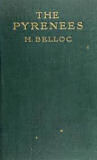 |
Methuen and Co., 1909, hbk, 340 pages
"The only object of this book is to provide, for those who desire as I do as I have done in the Pyrenees, a general knowledge of the mountains in which they propose to travel."
[...]
My chief regret is that the book will necessarily be too bulky to carry in the pocket; for it is meant to be not so much a lively as an accurate companion to the general exploration of those high hills which have given me so much delight."
[Preface, The Pyrenees] |
|
end
notes
- Département
- the above is the French way of spelling the word
that Anglo-Saxons spell as department.
Here at abelard.org, we use both
spellings when describing the French administrative
department, which is fairly equivalent to an American
state or British county.
- For a map of the modern
départements of France, see the
map at the abelard.org France Zone.
- The
French and the English spell compound words and phrases,
such as Pyrenees Atlantiques and Pays Basque differently
from us Anglo-Saxons. Also note that the French also
often pronounce words somewhat differently: dropping
final consonants in many instances, being more meticulous
to pronounce each vowel with a clearly different sound,
and usually pronouncing every syllable.
At abelard.org, we tend to ring the
changes between French and English spellings, and even
sometimes use a mixture, as in Basqueland!
But why is the French version of Pyrenees Atlantiques
spelt Pyrénées-atlantiques, and why does
Pays Basque not have an ‘s’ at the end of
the second word?
Pyrénées-atlantiques:
In French, with a double-barreled word, the second word
matches the first word on whether it is singular or
plural. In French, the Pyrenees is a plural word - the
collective noun for that range of mountains, so the
accompanying adjective (describing word: Atlantique)
also ends in ‘s’. In French, the second
word in a hyphenated compound noun is written in lower
case. This is why ‘atlantiques’ is in lower
case.
Pays Basque: In French, the word for
country, le pays, is singular. Thus the accompanying
adjective, Basque, is also given as the singular, that
is without an ‘s’ at the end.
- Pyrenees -
you wanna get technical? Go
look around this site!
- Col
- A mountain pass between two peaks. A col could
also be a gap in a mountain ridge. The Breech de
Roland near Gavarnie is one such col.
- Pic
- French for a mountain summit.
|


