abelard's home socialism, sociology, supporting documents described Children and television violence

Click for motorways and motorway aires in France.France zone at abelard.org - another France

link to news zone What is memory, and intelligence? Incautious claims of IQ genes quotations at abelard.org, with source document where relevant link to short briefings documents
click for abelard's child education zone Loud music and hearing damage Energy - beyond fossil fuels economics and money zone at abelard.org - government swindles and how to transfer money on the net visit abelard's gallery link to document abstracts

motorway aires: 10

Click to go to 'the highest, longest: the viaduct de Millau'

motorway aires [1]

aires on the magnificent A75 autoroute

aire de marvejols, viaduc de millau, viaduct de garabit

Motorways/autoroutes of France, showing the A75 autoroute including the Viaduc de Millau

This page helpful?
Like it ! Share it !

sketch map of the A75 from Clermont-Ferrand to Béziers

interactive map: hover with your mouse,
pink clickable areas change to a hand icon

france

new! Cathedrale Saint-Gatien at Tours  Cathedrale Saint-Gatien at Tours

Romanesque churches and cathedrals in south-west France updated: Romanesque churches and cathedrals in south-west France

 the perpendicular or English style of cathedral  Manchester cathedral

the fire at the cathedral of Notre-Dame de Paris
cathedral giants - Amiens and Beauvais

Stone tracery in church and cathedral construction illustrated
stone in church and cathedral construction

stained glass and cathedrals in Normandy illustrated graph

fortified churches, mostly in Les Landes

cathedral labyrinths and mazes in France
using metal in gothic cathedral construction

Germans in France
cathedral destruction during the French revolution, subsidiary page to Germans in France

Click for an introduction to cathedrals and stained glass in France.

on first arriving in France - driving
France is not England
paying at the péage (toll station)

Click for motorways and motorway aires in France.

Transbordeur bridges in France and the world 2: focus on Portugalete, Chicago, Rochefort-Martrou
Gustave Eiffel’s first work: the Eiffel passerelle, Bordeaux
a fifth bridge coming to Bordeaux: pont Chaban-Delmas, a new vertical lift bridge

France’s western isles: Ile de Ré
France’s western iles: Ile d’Oleron

Ile de France, Paris: in the context of Abelard and of French cathedrals
short biography of Pierre (Peter) Abelard

Marianne - a French national symbol, with French definitive stamps

la Belle Epoque
Grand Palais, Paris

Click to go to pages about Art Deco at abelard.org

Click to go to 'the highest, longest: the viaduct de Millau'

Pic du Midi - observing stars clearly, A64
Carcassonne, A61: world heritage fortified city

Futuroscope
Vulcania
Space City, Toulouse

the French umbrella & Aurillac

50 years old: Citroën DS
the Citroën 2CV: a French motoring icon

the forest as seen by Francois Mauriac, and today
Les Landes, places and playtime
roundabout art of Les Landes

Hermès scarves

Hèrmes logo

bastide towns
mardi gras! carnival in Basque country
country life in France: the poultry fair

what a hair cut! m & french pop/rock

Tour de France 2023s

Le Tour de France: cycling tactics illustrated

New translation, the Magna Carta

marker at abelard.org the a75 autoroute (clermont-ferrand to béziers)

Tour de France 2018

marker at abelard.org aire de marvejols
marker at abelard.org viaduct de millau
marker at abelard.org two elegant modern bridges to spot
marker at abelard.org viaduct de garabit

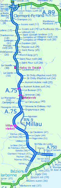
Motorway aires are designed to provide a suitable environment for relaxing, refreshing and recovering during the long, hard journeys. As well as facilities of often dubious nature, picnic tables and seats, a telephone kiosk, there are often optional extras such as a play area or a display related to some local interest or event.

the a75 autoroute (clermont-ferrand to béziers)

The A75 motorway (la Méridienne) runs from just north of Clermont-Ferrand in the north, southwards to Béziers, so crossing the Central Massif and adjacent areas of unusual geology. abelard.org visited the southern part of the autoroute. This section, of 340 km between Clermont-Ferrand and Béziers, is free apart from the toll on the Viaduct de Millau. (There are two sections still to be completed: the Lodève bypass - 13km, opening forecast for 2006, and the link between Béziers and Pézenas - 21 km, its opening forecast for the first quarter of 2010.)

In late 2005, this motorway is nearing completion (it was started in 1975). The Viaduct de Millau only opened in December 2004. This major construction plays a pivotal role, enabling the A75 to traverse the deep Tarn gorge rather than going down into the valley and past the town of Millau, a journey with hours of traffic jams.

This nicely surfaced motorway is like a switchback as it sweeps through volcanic hills and limestone gorges, giving many attractive views, some endowed with a suitably located aire, like the Aire de Marvejols. There are pretty and impressive road bridges spanning the motorway, in strong yellow, blues, rust red.

As well as the astounding Viaduc de Millau, there are many other smaller viaducts along the way, to span the undulating landscape. (You can expect your ears to ‘pop’ fairly frequently.) This bridging started in the 19th century, when it was railways rather than roads that were the major transport. The Viaduc de Garabit comes from that era, an spectacular piece of iron engineering.

For travellers on this attractive motorway, there are more aires with games, shops and greater parking space than the ones we visited. There are also other diversions nearby, on leaving the road like the town of Chaude-Aigues, for instance, near exit/sortie 34, with its geothermal power station taking advantage of the 82°C springs.

aire de marvejols

This is a fairly small aire at about 800 metres (2600 ft) height, with commanding views which may inspire some to raptures. It is a good place for aspiring geologists to observe U-shaped valleys and other geological esoterica. This aire is only accessible from the northbound side of the A75. There is a similar aire on the southbound carriageway, about 200 metres further north. They are not linked.

The picnic areas are arranged for scenic repasts 
          overlooking the vast vistas.
The picnic areas are arranged for scenic repasts overlooking the vast vistas.

There is a semi-circular viewing map to aid recognition of more distant towns and peaks. [Aire car parking behind.]
There is a semi-circular viewing map to aid recognition
of more distant towns and peaks.

viaduc de millau

The viewing point for the Viaduc de Millau [related page], together with the visitors’s centre, is now accessible in both directions using slip roads from the A75.

The Viaduc de Millau from the A75 motorway

From here, there is access to both the exhibition centre [open from 9am to 7pm, last entry is at 6.30pm] and the viewing point. The viewing point is approximately 30 minutes walk away uphill, but the climb is very steep in places, and is unmetalled. There are some benches on the way with good views over the valley towards Millau.

The footpath winding up to the viewing point for the Viaduct de Millau


two elegant modern bridges to spot

Antrenas bridge on the A75
Antrenas bridge on the A75,
designed by Jacques Berthellemy , Emmanuel Bouchon, Jacques Resplendino, Michel Virlogeux

Truc de la Fare bridge on the A75. Image by Lafraque
Truc de la Fare bridge on the A75
bridge designed by Michel Virlogeux,
who also worked on the Viaduc de Millau and designed the Ile de Ré bridge

viaduc de garabit

the viaduc de Garabit aire
The aire is a little way off the motorway and gives views of both the viaduct and the valley it spans. There is a modern box of an exhibition centre, with a potted, illustrated history in several European languages on large panels. (There are also printed versions to take away.)

This aire is on the west side of the motorway, next to the southbound carriageway. However, the aire is accessible from both directions of the motorway, those coming north drive under the motorway by a road tunnel.

The Viaduct de Garabit, built in 1884, spans the river Truyère in Cantal

some history
Built by the Eiffel company in 1884, this railway viaduct is regarded as the grandfather of the viaduc de Millau, opened rather more recently in 2004. The Eiffel Tower in Paris is la petite soeur, the little sister, of the viaduc de Garabit. The viaduct is illuminated at night. It stretches between Saint-Flour and Saint-Chély.

Gustav Eiffel had previously tested this bridge-building technique with a smaller bridge at Porto in Portugal. It was after for years of work that the two halves of the arch, springing from either side of the River Truyère, were joined together. Although the main reason for building the bridge was commercial - to transport goods manufactured, such as Langedoc wines, in the south of France to the North and Paris, in the 1900s the railway line became the means for Auvergnats [people born in the Auvergne region] to leave Paris, from the Gare d’Orsay, and return home for holidays.

The viaduct deliberately has no infilling between the many iron ties that make up the arch and the roadway it supports. If the structure had been made into a solid structure, with solid panels between the ties, there would be an impossibly strong resistance to the winds channeled down the Tarn valley. The viaduct would have been blown away.


Old postcard showing a steam train passing over the Garabit Viduct, circa 1910

In 1934, the railways converted from coal-fired locomotives to ones powered by electricity. Then in 1937, six competing railway companies were merged into one nationalised company, the SNCF - la Société Nationale de Chemins de Fer, or National Company of Iron Roads. The maximum allowed speed for trains going over the viaduct is 40 km per hour.

During the Second World War, in 1944, the Mount-mouchet marquis [French resistance fighters] were based nearby and were very active in cutting the means of communication for the German invaders. They blew up the stone bridges near the railway station, and were looking to the viaduct as another target. However, the locals thought otherwise and mounted a 24-hour guard to prevent any such sabotage.

The viaduc de Garabit has been in a number of films. In The Cassandra Bridge, a disaster movie with Sophie Loren, Burt Lancaster, Martin Sheen and Ava Gardner, made in 1976, the viaduct apparently collapsed into the River Truyère below.

structural statistics

  • Length: 564.65 metres
  • Height: 122.2 metres
  • Central arch: 165 metres across
  • Weight: 3,249 tonnes iron
  • Painted area: 51,000 m²
  • Masonry used:20,409 m³
  • Cost in 1884: 70,000,000 € [£50,000,000 / $85,000,000]
  • Construction: cast ironwork mounted stone bases

marker at abelard.org

The aire Marvejols is in Département 48 - Lozère.
The Viaduct de Millau is in Département 12 - Aveyron.
The Viaduct de Garabit is in Département 15 - Cantal.

end notes

  1. aire: in this context, an area —
    aire de loisirs: recreation area;
    aire de pique-nique: picnic area;
    aire de repos: rest area;
    aire de services: services , motorway (GB) or freeway (US) service station.

  2. The A75 motorway is being kept practically free to encourage commercial traffic travelling from Paris to the Mediterranean coast to use this new route, rather than the heavily-subscribed A6 motorway running through the heavily industrialised Rhone valley.

  3. “The Massif Central, a roughly triangular upland area covering one-sixth of France, contains a landscape of enormous variety characterised by a number of distinctive landforms. Water is an important and dynamic component of this landscape system. The striking gorges of the limestone Causses reflect the erosive power of the Massif's principal rivers. Today these waters have become a major recreational attraction and have brought an important source of revenue into the region.” [Quoted from discover.ltd.uk]

marker at abelard.org

“The Cévennes can be divided in 3 broad regions, mainly based on the geology which [...] shapes landscape, climate and architecture.
1) The Southwest, Causses and calcareous canyons. Causses are big flat plateaus, cut by deep gorges such as Gorges du Tarn. The traditional houses are made of carbonaceous rocks. The climate is quite rough, especially in winter: high winds, snow and cold.
2) Two big granitic mountains, Mont Lozère (North) and Mont Aigoual (South). Houses made of granite, and typical mountain climate.
3) Southeast. metamorphic-rock (schists) Cévennes. Characterized by long crested hills and deep valleys, not many flat parts. The houses look severe because made of dark schist, but the climate is the nicest of all of Cevennes, as it is buffered by Mediterranean winds.” [Quoted from virtualtourist.com]

marker at abelard.org

“Mont Lozère is a large upland region in the southeast of the French Massif Central. It is part of a northeast-southwest trending mountain range, the Cévennes. This range forms part of the Mediterranean-Atlantic watershed. West draining streams join rivers such as the Lot and the Tarn which drain to the Atlantic. On the east and southeast sides of the range, streams drain into rivers which join the Ardèche and the Gard, part of the Rhône drainage system which flows into the Mediterranean through the delta of the Camargue, an important wetland habitat.” [Quoted from virtual-geology.info . This page explores the region’s geology in detail, including maps, charts and photographs. It provides geological background for an Oxford Brookes University field course.]

marker at abelard.org

The geological history of the Cevennes.

on first arriving in France - driving motorway aires, introduction
travelling by rail to and within France individual aires                                             
A75 autoroute from Clermont-Ferrand to Béziers and its aires Les Pyrénées, A64 Poey de Lascar, A64
A89 autoroute from Bordeaux to Clermont-Ferrand and beyond - aires Pic du Midi, A64
Hastingues, A64
Dunes, A62
Mas d’Agenais, A62
A7 - aires on the busy A7 autoroute from Lyons to Marseille Pech Loubat, A61
Port-Lauragais, A61
Mas d’Agenais, A62
Garonne, A62
A9- aires on the motorway to Spain Ayguesvives, A61
Renneville, A61
Catalan village, A9
Tavel, A9
A62 - aires on the autoroute of two seas three aires on the canal du midi, A61 Lozay, A10
Poitou-Charente, A10
A65 : the autoroute de Gascogne, from Langon to Pau Carcassonne, A61 Les Bréguières, A8
A64 and A61 - aires on the other autoroute of two seas  
A83 motorway in Poitou-Charentes - aires A63: the French Wild West, Bordeaux to the Spanish border - formerly the N10
A837 motorway in Poitou-Charentes - aires A20 - aires on the Occitane autoroute, from Brive to Montauban
A42 and A40 motorways - aires from Lyon to Switzerland and Italy A87 motorway and its aires in Poitou-Charentes

abstracts | briefings | information | headlines | loud music & hearing damage | children & television violence | what is memory, and intelligence? | about abelard

email abelard email email_abelard [at] abelard.org

© abelard, 2005, 04 october
v1.2

all rights reserved

the address for this document is https://www.abelard.org/france/motorway-aires10.php

The Millau viaduct